lOgaREA
Plans and Prices
Photos
Videos
Editorial
Blog
lOgaREA
Sign In
Sign Up
Sell Images
...
0
All Images
Photos
Editorial
Videos
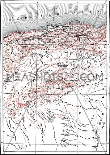
Map of the Country between Khartoum and Tchelga, vintage engraved illustration. Le Tour du Monde, Travel Journal, (1865).
Description:
Map of the Country between Khartoum and Tchelga, vintage engraved illustration. Le Tour du Monde, Travel Journal, (1865).
Stock Image ID:
147089
Owner:
Patrick Guenette
Title:
Map of the Country between Khartoum and Tchelga, vintage engravi - photo
Map of the Country between Khartoum and Tchelga, vintage engraved illustration. Le Tour du Monde, Travel Journal, (1865).
Resolution
Size
Price
S
867 x 569 px jpg
License: Royalty Free
[More Info]
( 2.9" x 1.9" @ 300 dpi )
$7.00
M
1735 x 1139 px jpg
License: Royalty Free
[More Info]
( 5.8" x 3.8" @ 300 dpi )
$16.00
L
2930 x 1924 px jpg
License: Royalty Free
[More Info]
( 9.8" x 6.4" @ 300 dpi )
$36.00
XL
6475 x 4251 px jpg
License: Royalty Free
[More Info]
( 21.6" x 14.2" @ 300 dpi )
$48.00
$48.00
New Flexible Plans and Packages
Similar Media
Media Keywords
ancient
antique
art
artwork
atlas
black
boundary
capital
city
continent
country
drawing
engraved
engraving
etching
geography
history
illustration
khartoum
location
map
old
picture
republic
state
sudan
tchelga
vector
vintage
white
Share this photo :
Processing

 Processing